
Competencies
Informing Design’s core competency is its signature approach to mapping that “de-complexifies” travel routes, enabling quick mastery of complex urban areas by motorists, pedestrians and bicyclists via sign systems, map kiosks, printed maps, apps and web sites. Pittsburgh’s infamous complexity turned out to be the perfect laboratory for the firm. See the “Gridding the Ungriddable” case study for the story of how it all began.
CITY DE-COMPLEXIFYING:
COMPLETE CITY SOLUTIONS
TRAFFIC SIGN SYSTEMS
ROAD MAPS
3-D MODEL PEDESTRIAN MAPS
PARK AND TRAIL SYSTEM MAPS
BIKE ROUTE PLANNING AND MAP
TRANSIT MAPS AND SCHEDULES
BIG MUSEUM AND MEDICAL CENTER HALLWAY MAPS
MARATHON MAPPING
STADIUM PARKING SIGN SYSTEMS
AIRPORT SIGN SYSTEM
NEIGHBORHOOD SHOPPING MAPS
truck route Maps
Interpretive Panels
WEB AND APP INTERFACES:
DOUBLE-MAP MASHUP SITES
BOBSMAPS.COM
HOMELESS SERVICES APP
BUS-TRONIC: THE TIMETABLE OF THE FUTURE
BIKE MAP APP
Research/Publications
Highway Sign System Development
Spatial Information Theory
City De-complexifying
Complete City Solutions
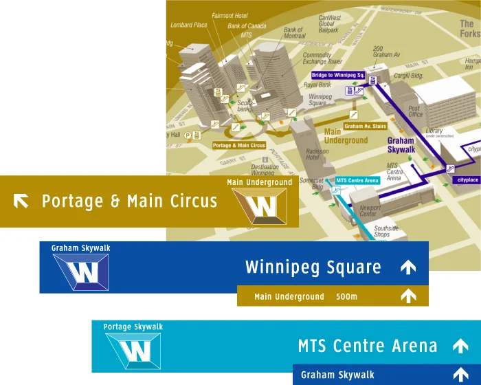
In Nashville, Winnipeg and Winston-Salem, the firm has had the opportunity to create multi-modal signing and interactive solutions encompassing traffic and pedestrian/biking routes, all based on a comprehensive remapping of the Cities.
Traffic Sign Systems
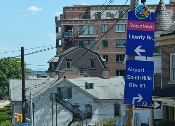
In addition to numerous smaller systems, the firm has designed four of the largest “wayfinding” traffic sign systems in North America: Maryland State-wide, Pittsburgh, Nashville, and Winnipeg.
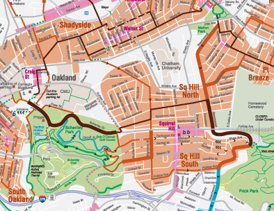
Road Maps

In addition to maps developed under sign system projects, the firm has re-mapped for tourist purposes the core areas of many major cities in North America, including the first completely new map of Manhattan after 9/11 (untangling both the financial district and Greenwich Village) and a new kind of Washington, D.C. map that renders travel there as simply as a game of chutes and ladders.
3-D Model Pedestrian Maps
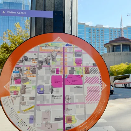
The firm’s approach to pedestrian maps begins with the creation of a 3-D computer model. Then for each site where a map kiosk is to be installed, a custom-oriented map tailored to that precise location is generated. This, coupled with our insight into the design of the “less embarrassing kiosk,” results in sidewalk maps that are remarkably engaging and offer mastery of where to head in a glance.
Park and Trail System Maps
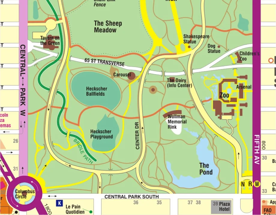
Informing Design has untangled the infamous meanderings in Central Park as well as the complex trail networks in Pittsburgh’s equally large Frick and Schenley Parks. A key insight in the Central Park project was the discovery of a grid based on the not-obvious walk-acrossable routes between the East and West sides. The firm also did a comprehensive remapping of the Greenways system in Nashville, both in print form and as a double mash-up map system for the web.
BIKE ROUTE PLANNING AND MAPping
It came as a pleasant surprise when Informing Design discovered in 2008 that its de-complexifying approach to road and trail mapping could also be used to solve urban bike routings. See “Urban Bike Maps, sans spaghetti” for the full story of how it worked in Nashville and Pittsburgh. (Bob Firth, the firm’s founder, has been an avid cyclist for decades.)
TRANSIT MAPS AND SCHEDULES
Informing Design has long had an interest in transit system maps and schedules, having been responsible for several editions of the Pittsburgh System Maps in the early 2000s. The firm has implemented its own kind of “spider maps” for bus shelters in both Pittsburgh and Winnipeg. It developed a new kind of subway map of Manhattan. And it is an active area of research and development for the firm, with a new “Bus-tronic: the timetable of the future” app due out later this year. The app is based on new insights into how to make complex transit systems grasp-able at a glance without violating geographic scale. See “Disagreeing with the London Underground Map” for the full story.
Big Museum and Medical Center Hallway Maps
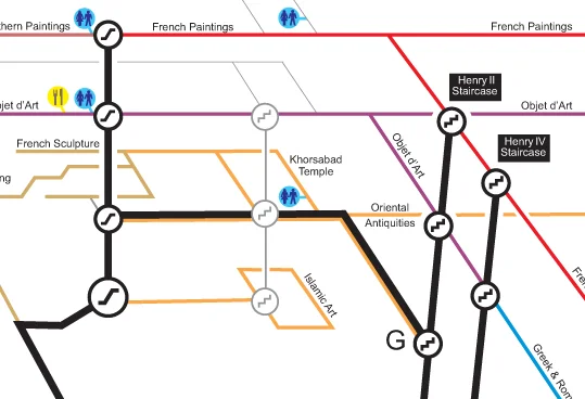
In the mid-nineties, Bob Firth was invited by the Louvre to study their recently implemented wayfinding maps and signage. He discovered a flaw in the new map system that had been implemented under I.M Pei, which turned out to be a taboo subject. Bob went on to design his own de-complexified solution in 3-D. He then had the opportunity to apply this approach to mapping the interior hallway system for a medical center near Pittsburgh and to the Carnegie Museums of Art and Natural History in Pittsburgh.
Marathon Mapping
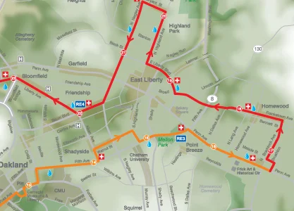
Starting with its discovery of a “secret escape route” from the city’s East End on Marathon Sunday, the firm went on to become the de facto cartography to the Pittsburgh Marathon. Over a dozen custom maps are prepared annually, including elevation maps, double mash-up online maps, maps for administrative purposes, and for helicopter surveillance. See the “Escape from Pittsburgh” case study for the full story.
Stadium Parking Sign Systems

Following the success of the city-wide Wayfinder Sign System — including its system of parking signs for Downtown and in shopping districts — the firm was tapped to organize event parking routes for the dozens of parking facilities serving Pittsburgh’s Heinz Field. A new color-coded system was created with its own system of directional signs. See this summary map of how the routings were organized. More recently, the firm designed the parking sign system for football-crazed State College, Pennsylvania’s downtown.
Airport Sign System
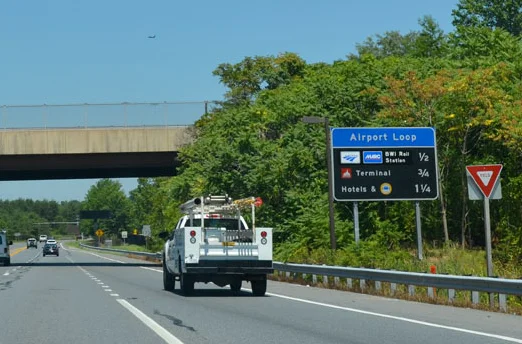
The firm designed the traffic sign system for the Thurgood Marshall BWI Airport as well as sign systems for the entire region of hotels and business parks around the airport. A new feature was the creation of an “Airport Loop” which greatly simplified guidance and reduced the need for signing, as motorists followed the simple loop markers to carry them from one destination zone to another.
Neighborhood Shopping Maps
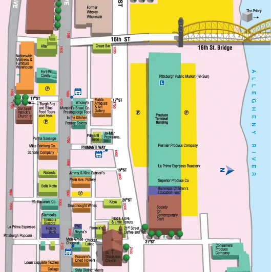
For many years, the firm was responsible for what became the “most requested” map pamphlet in Pittsburgh: the shopping map of the popular Strip District open-air markets and nightlife area of the City. It included the firm’s famous de-complexifying map of Downtown on side two.
Truck Route Maps

The firm developed a new kind of “islands and bridges” Truck Route map of the entire Island of Montreal, including an ingenious printed version that unfolds easily from a Rand McNally Atlas-sized format.
Interpretive Panels
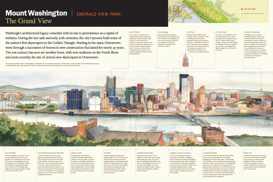
With a star artist on its staff, Yelena Lamm, the firm has had the chance to produce dramatic results with interpretive displays. Most recently, Informing Design was tapped to design 10 new interpretive panels that run the length of the Grandview promenade overlooking Downtown Pittsburgh – a promenade that is one of the city’s top tourist attractions. Some years earlier, the firm produced two giant wall displays for the History Center on the theme “What Makes Pittsburgh Pittsbugh.”
Web and App Interfaces
Double-Map
Mashup Sites

Informing Design pioneered the use of double-mashup maps that display synced moveable maps side by side — one serving as an overview and the other simultaneously showing close-up details. See it applied to the Pittsburgh Marathon and Nashville’s Greenway System.
Bobsmaps.com

For several years the firm operated the bobsmaps.com website, with free downloads of its top Pittsburgh maps. Its most active use was at the beginning of pro sports seasons (for parking maps) and in the lead-up to the Marathon (for its guides to getting around on Marathon Sunday). It also featured Medical Center Parking maps, biking maps, and park maps. Bobsmaps.com is now shuttered.
Homeless Services App

Informing Design has released BigBurgh.com, an app designed to capture and keep up-to-date all of the available services for the homeless in Pittsburgh, including an “Uber for the Homeless” feature that will enable homeless to get in touch with car-based professional help at the push of a button. It is all packaged like a colorful mobile game to make it appealing and easy for homeless youth to use (60% of whom have access to a smartphone).
Bus-tronic: the timetable of the future

Based on its discovery of how to simplify transit maps without distorting geographic scale, the firm is developing a new kind of app that will provide an instantaneous grasp of how the Pittsburgh transit system works city-wide and of just the bus times that are needed by location, with a merging of both real-time and scheduled bus times. See the “Disagreeing with the London Underground Map” case study for the full story.
Bike Map App
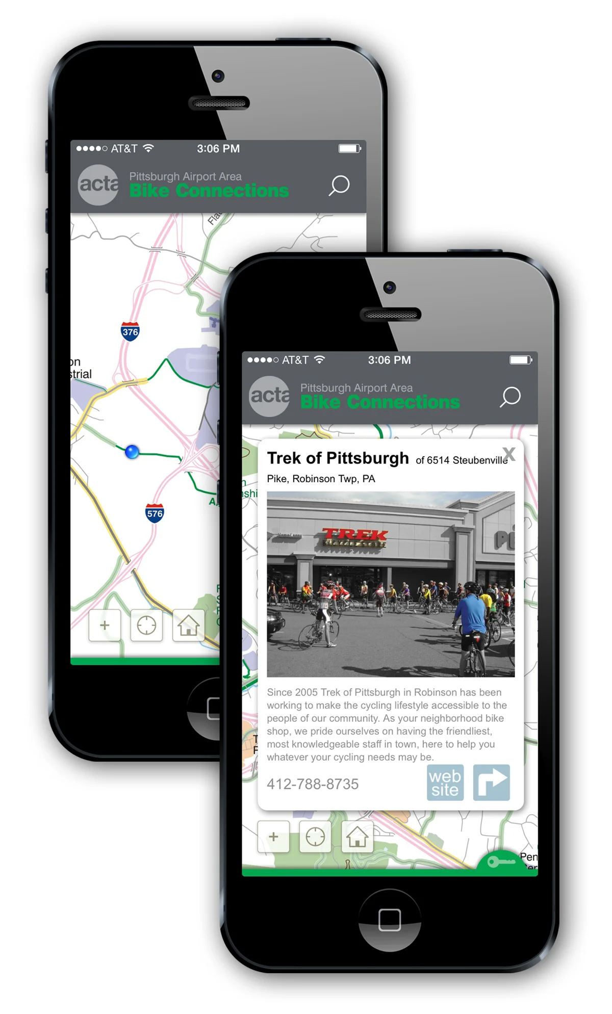
For the Airport Transportation Corridor Association in Pittsburgh, the firm developed a new map of bike routes in and around the Airport Region, and then encapsulated the map in a new ACTA Bike Map app, for both iOS and Android.
The CityTUNR App

The firm is developing a new kind of map app for cities based on its de-complexifying approach. It is designed to give the user the quickest-possible grasp of “with-it” fresh and local dining, shopping, and “fun” opportunities, based on human-curated listings. Look for it in the fall of 2016.
RESEARCH/PUBLICATIONS
HIGHWAY SIGN SYSTEM DEVELOPMEN

Bob Firth, founder of Informing Design, first presented his mapping tool as one of three speakers invited to a specially assembled symposium on “Getting Lost” at the National Academy of Sciences in Washington in 1996. It was there that he met one of the leading state highway officials in the country, Tom Hicks, then head of the Office of Traffic and Safety at the Maryland State Highway Administration. By 2001, Bob was tasked with developing a whole new kind of tourist-oriented sign system based on his concepts, a system which will eventually replace all previous tourism-related systems in the State of Maryland.
Spatial Information Theory

Bob Firth has presented his de-complexifying concepts at the "International Conference on Spatial Information Theory" in Germany in 2008, and at the second “Pennsylvania and Friends Spatial Cognition Symposium” at Penn State in 2015. He has been a frequent guest lecturer at the School of Information Sciences at the University of Pittsburgh. In 2010, he was a co-author of the paper, “The Tricky Part: When Directions Become Difficult,” published in the Journal of Spatial Information Science. He is currently at work on a monograph entitled, “Cities Untangled: Aggregate Effect Mapping of Travel Routes.”